- The 2018 Camp Fire in California burned 52,000 acres the day it started, killing 85 people and destroying over 16,000 homes.
- The 2021 Marshall Fire in Colorado was driven by winds over 100 mph, traveling 3 miles within the hour it started and burned more than 1000 homes.
- The 2023 Lahaina Fire in Hawaii killed 101 people and destroyed more than 2200 structures in 2 hours.
A new study in Science Advances redefines these as ‘fast fires,” a definition that explains how they grow and their social impact. Noting that “Most of the area burned in extremely large events is from the growth on a single day,” the researchers argue that the fire risk is more related to the speed at which they grow, fire growth rates (FGR), than the area burned.
Fires may be growing faster due to warming trends - fast fires often occur during downslope wind events in dry autumn conditions, which have increased in both frequency; vegetation shifts to more flammable fuels – invasive grasses contribute to these faster, larger fires, which in turn involve, more challenging to contain longer fire lines; and human ignitions, which have steadily increased by 9% since 1992, combined with high winds, are significant drivers of fast fires. (Nearly all wildfires threatening homes are started by humans, not lightning, because “lightning generally does not occur under high-wind conditions due to the constraints surrounding their associated storms.” However, little is known about fast fires’ underlying pattern and distribution.
The data supporting their contention comes from a dataset called FIRED (Fire Event Delineation), which covers over 60,000 fires and uses satellite images to calculate daily FGRs. The data is correlated with information from more than 2 million property and housing records, allowing estimates of “ exposure to wildfires (up to 4 km away)” and US “data on structural damage, enabling us to evaluate both wildfire exposure and its actual impact.”
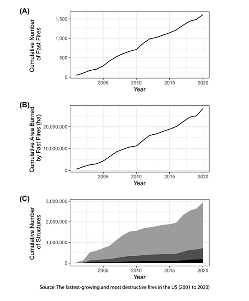 Fire growth rates (FGRs) were highly variable, with fires averaging 630 acres/day and maximum rates reaching up to 530,300 acres/day. The day of maximum FGR accounted for 38% of the total burned area, with extreme fire weather driving rapid fire growth, which impacts suppression efforts. Over 90% of fires lasted less than 20 days, and 83% reached peak growth within 5 days, varying by vegetation type.
- Mean and maximum FGRs vary by land cover, with the fastest-growing fires in grasslands and savannas. Fast-moving fires, particularly in grasslands, with fine, flashy fuels and low wind friction [1], grow rapidly within the first few days.
- When accounting for societal impacts, Fast-growing fires are the most destructive, with fires exceeding 4,000 acres/day linked to the majority of structure damage. These fast fires represent only 2.7% of all events but account for 60% of the burned area and 89% of structure loss. [2]
- Between 2001 and 2020, fast fires impacted 58 of the 85 level III ecoregions (regions identified by similar climate, geology, vegetation, wildlife, and soil types), threatening over 1.7 million structures and causing $18.9 billion in suppression costs, along with 337 fatalities (66% of total) and 5623 injuries (43% of total).
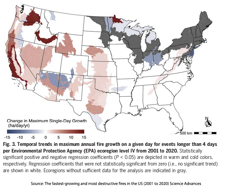
- From 2001 to 2020, fire growth rates increased significantly across much of the Western US, with California experiencing the most significant increases. Fires in California grew 398% faster by 2020 compared to 2001, and fires grew 249% faster across the Western US. This trend was accompanied by a 323% increase in burned areas near built-up regions.
Do Models Matter?
Our current wildfire models are based on the probability of their occurrence as well as the intensity and severity of the fire. They are used to implement mitigation strategies, such as brush removal around homes, and to place and plan resources. The researchers argue that the model has a critical gap in not explicitly considering the speed of fire growth.
“The speed of a fire determines (i) whether firefighters are more focused on evacuation than home protection and (ii) how effectively they can extinguish burning firebrands [burning materials that are blown by wind from one place to another] and new ignitions on structures before the home becomes fully involved.”
Human growth into the wildland-urban interface, where fires are more likely, makes applying our models frequently a matter of life and death if not increasingly higher financial costs.
As wildfires grow faster and more dangerous, it's clear that current models for predicting and fighting them are lagging. Incorporating fire growth rates into wildfire strategies could be the key to saving both lives and homes. With more people moving into high-risk areas and the climate creating ideal conditions for fire, adapting our approaches to these new, rapid threats is more crucial than ever.

Chuck Dinerstein, MD, MBA
Director of Medicine
Dr. Charles Dinerstein, M.D., MBA, FACS is Director of Medicine at the American Council on Science and Health. He has over 25 years of experience as a vascular surgeon.